TOP][Shinetsu Region
MT.Ontake][How to get there][Accommodation]
trail1][trail2][trail3][trail4][trail5][trail6
MT.Ontake

Recommendation season
From end of June to  beginning of October.
The elevation of this trail is from 2200M to 3067M.

Free Trail Map
Tanohara - Kongodoshi -KYugome - Otaki-chojo Hut - Mt.Ontake - Ninoike - Tanohara
Total distance 8km
Total time 6hrs.

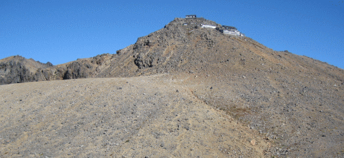
Mt. Ontake is a dormant volcano with 3067m elevation and highest mountain among the neighbours in Norikura volcanic zone.
There are 5 lakes around high and steep independent peak. Mt. Ontake is very elegant and also famous for faithful mountain in that long history same to Mt. Fuji and Haku-san. So that still attracts not only a lot of trekkers but many faithful people with completely white unique costume, wooden stick, and [Tabi], Japanese traditional sox and shoes.
You are never tired of the view from the top and that absolutely gives you the great impressions by cobalt blue lakes. gorges with eruptive smoke, and a variety of routes.
Kaida-kogen Tourist Association
Kiso,Otaki village Web
Bus Time Tabe
Between Kisofukushima station and Otaki station
Ontake gondola
Ontake Ski Area
Live Camera
Mt.Ontake From Kiso district
Mt.Ontake From kaida-kogen district
Weather
Copyright(c) TOZAN. All rights reserved.
Base template by WEB MAGIC.