Recommendation season
From middle of May to end of October.
The elevation of this trail is from 685M to 1819M.
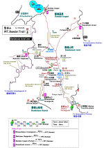
Free Trail Map
Omote tozanguchi - Ichigome - Numanodaira - Koboshimizu Hut - MT.Bandai
- Omote tozanguchi Total distance 6km Total time 6hrs.
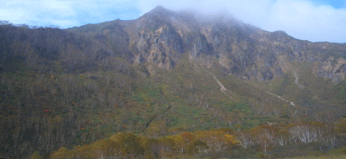
The Mt. Bandai is the representative mountain in northern Japan, located
in Fukushima prefecture.
It is called as Aizu Fuji.
Current rugged feature was formed by volcanic activity in 1888 and some
beautiful lakes such as Goshiki lake were also.
That is the great view.
The south side of the mountain is called "Omote-Bandai" meaning
front of Mt, the north side called [Ura-Bandai], meaning rear of Mt. The
appearance looks very different by seeing from south or north.
That from south looks very rough with original mountain partially collapsed.
There are some routes to the summit, but [Omote] route on this site, taking
three and half hours to the summit, is recommended because you can not
only conquer to the summit, but enjoy your way there by different views
aroud you.