The Japanese area is about 378,000 square kilometers, 2/3 of the countries
is mountainous.
Japanese land consists of 4 main islands, i.e. Honsyu, Shikoku, Kyusyu,
and Hokkaido, and about 4000 scattered small islands.
The land is surrounded by ocean and some volcanic chains run across, so
it is one of the world most shaky earthquake zone.
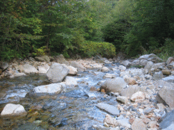
A lot of rapid streams, represented by 3 major rapid streams, Mogami-river,
Fuji-river, and Kuma-river, created very variable land, mountains, deep
ravines and so on with a lot of hot spring.
In the center of Mainland, Honsyu, there are three long ranges, Hida, Kiso,
and Akaishi with mountains over 3000m and called the Northern, the Centeral,
and Southern Alps respectively. They are generally called Japan Alps or
The roof of Japan.
It was named by English guy, Weston in 1896.

 The Volcanological Society of Japan

Ten highest mountains in Japan
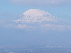
1.Mt. Fuji (3776M)
Fuji-san
2.Mt. Kita (3192M)
Kita-dake
3.Mt. Oku-Hodaka (3190M)
Oku-Hodaka-dake
4.Mt.Ainodake(3189M)
Aino-dake
5.Mt. Yari (3180M)
Yari-gatake
6.Mt. Arakawa (3131M)
Arakawa-dake
7.Mt. Akaishi (3120M)
Akaishi-dake
8..Mt. Karasawa (3110M)
Karasawa-dake
9.Mt. Kita-Hodaka (3106M)
Kita-Hodaka-dake
10.Mt.Obami(3101M)
Obami-dake
The name of mountain consists of area name followed by

(yama) , ***san or ***

(dake).
(yama) and ***san generally mean the peak alone, and ***
(dake) generally means the ranges, but that is not strict rule.